Connecticut: On The Inland Sea
and Fishers Island Sound Paddle
By Tamsin Venn. Photos by Steve North.
Although the Connecticut Coast is densely populated, the sea kayaker has the great advantage of being able to launch car-top boats in Long Island Sound without the high fees charged for putting power boats or sailboats in the water. Other benefits include no need to get tied up in boat traffic while waiting for bridge openings and no reservations required months or years in advance for moorings.
The kayaker also has the benefit of the sheer variety of paddling. Along the 250 miles of Connecticut Coast, every kind of water is available: from sound to bay; river to cove; salt marsh to creek - from fully exposed water to winding passageways you could lose yourself in. The main interaction is with Long Island Sound, which is generally protected because the arm of Long Island acts as a buffer to the Atlantic. An east or west wind, however, can bring up some strong currents and sizable waves.
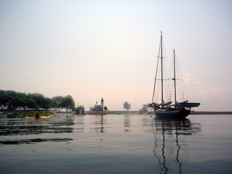
From sheltered coves to relatively exposed offshore islands, Connecticut offers a plethora of paddling venues.
The shoreline offers quiet refuges wedged between industrial activity. Smaller towns like Stonington, Mystic, Clinton, and Guilford with white colonial homes and one-way streets lie between the commercial sprawls of Stamford, New Haven, and New London. Shoreline is the only visual access to some of Connecticut's more exclusive neighborhoods, if you're interested in a coastal real estate jaunt. It is pleasant to use the many white church steeples as onshore navigation aids.
Many houses, beaches, marinas, fish piers, jetties, lighthouses, power plants, and harbors all blend together in a dynamic mix of past and present, tourism and commerce, primary residences and weekend homes. Nuclear submarines motor into Groton. Lobster boats and dragger fleets work away. The last commercial fishing fleet in the state operates out of Stonington and has an annual blessing of the fleet in July. Antique boats sail in and out of Mystic. All are reminders of the strong historic maritime economy from the days when New London, Mystic, and Stonington were major whaling ports.
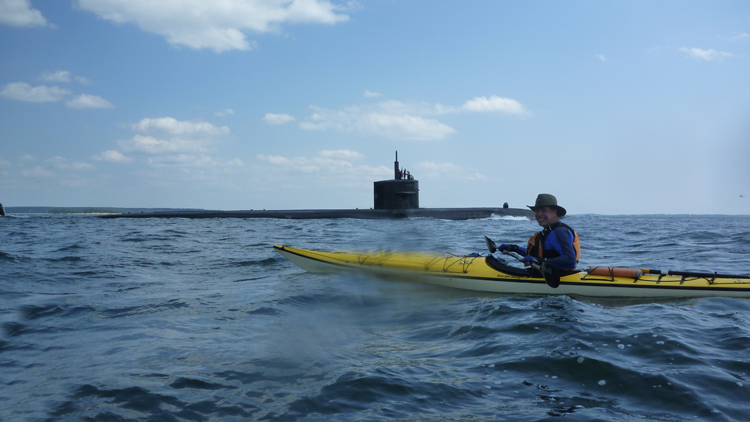
Paddling on Long Island Sound can offer many surprises, none more astounding than the sudden appearance of a nuclear sub in your path.
Generally, the farther east you go, the less crowded the shoreline becomes until you arrive at the beautiful Barn Island marshlands at the end of Fishers Island Sound. Many local Connecticut sea kayakers tend to paddle east instead of west.
Off-season trips before Memorial Day and after Labor Day are highly recommended to beat the confusion of wakes produced by motorboats and the traffic crush, which some paddlers say is worse than the Connecticut Turnpike.
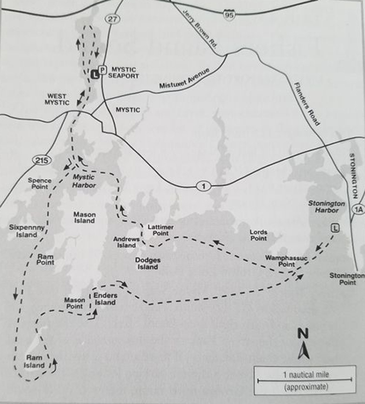
Fishers Island Sound
Fishers Island Sound Paddle
Mystic Seaport to Stonington
Charts and Maps: NOAA # 13214 at 1:20,000 or NOAA Small Craft Chart #12372 at 1:40,000, Long Island Sound, Watch Hill to New Haven
Trip Mileage: 12.5 miles
Access and Directions:
Mystic Seaport: From I-95, take exit 90, then follow CT 127 (Greenmanville Rd.) south. Pass the Seaport entrance. Just past the entrance, turn right on Isham Street. Use the ramp at the end of the street. Parking is limited. If there are no spaces, it may be possible to park in the Seaport parking lot across the street.
Groton Town Ramp: Follow CT 127 south past the Seaport, turn right on Willow Street, then right on East Main Street, which turns into West Main Street across the drawbridge. Turn left on Water Street just across the bridge. Bear left at Captain Daniel Packer Inne restaurant. The town boat ramp is on the left. On street parking only.
I-95 Bridge: Put-in is under the bridge on the river's west side. From West Main Street, turn right onto Pearl Street, left onto Grove, which turns into River Road. Parking area is on the right just north of the I-95 overpass. Parking for eight cars.
Esker Point Beach, Groton Long Point: Follow CT 215 (Groton Long Point Road) south of Mystic; at junction with Marsh Road. Rest rooms, snack concession in season, picnic area with hibachis and picnic tables. Free parking.
Camping: No established site
Tidal Range: 2.3 feet at Noank; 2.8 feet at Stonington
Caution Areas: A great deal of motorboat traffic travels in and out of Mystic Harbor.
Resources: Connecticut Coastal Access Guide. Click on Cartop Boat Launch.
This trip takes you out past the inviting rocky islands in Fishers Island Sound to scenic Stonington Harbor. The trip's highlight is paddling by the historic boats of Mystic Seaport, a replica of a nineteenth-century waterfront community and the largest maritime museum in the country.
Start at Mystic Seaport and paddle north under the bows and sterns of more than 13 historic vessels, including the whaler Charles W. Morgan and the training windjammer Josepth Conrad. Then paddle down the Mystic River toward Fishers Island Sound, a distance of about three miles.
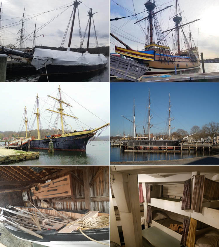
In the off season, you may see ships wintering at Mystic Seaport, or under repair. Top L: Reproduction of the slaver Amistad stored for the season. Top R: Mayflower II under repairs for the 400th anniversary of the Pilgrim's arrival in the New World.
Center Left: The training vessel Joseph Conrad, a typical windjammer. Center R: .Charles W. Morgan whaleship, a regular exhibit. Bot L: A whaleboat and display of flensing tools. Bot R: The Morgan's fo'cs'le or crew quarters. Photos by David Eden.
Paddle under the Mystic River's famous bascule drawbridge, which raises from May 1st to October 31st at 40 minutes past the hour from 7:40 a.m. to 6:40 p.m., otherwise on demand. Then paddle under the railroad bridge. You will hear Amtrak roaring by. Pass several marinas and slips, waterside condos, and restaurants. Stay to the right (west) of Mason Island, the end marked by a sandspit. To the right, is the Mystic Shipyard with hundreds of vessels and just beyond marked by a white church steeple, is Noank. The town's great distinction during the 1880s was being home to the largest fisheries business in Connecticut. Also, Abbotts in Noank is the biggest lobster pound in southern New England, take out window currently open. At the south tip is the deactivated Morgan Point Light, a private summer home renovated in 1991, including a new lantern room fashioned by the U.S. Lighthouse Service. The granite structure, resembling more a house than a tower, is similar to those found in Greenwich and Norwalk.

L: The famous bascule bridge1. R: Abbott's Lobster in the Raw.
Paddle past the beach at Ram Point, a nature preserve - look for oyster catchers. Then head straight out to privately owned 16-acre Ram Island, once site of an exclusive Victorian era hotel where steamships from Boston and New York City dropped passengers twice a day. Fires in 2013 and 2014 destroyed the barn and home that was there. Your view is dominated by the long hulk of eight-mile-long Fishers Island to the south and the brown-striped lighthouse on Latimer Reef to the east. Built in 1884, the cylindrical spark-plug-shaped lighthouse marks Fishers Island Sound. While there may be wild conditions nearby at The Race just off the west end of Fishers Island, within Fishers Island Sound conditions can be benign. Strong southeast winds can make the going a little rough, however, as you struggle to avoid taking the waves straight on a beam. Use the peninsulas and points for wind lees in such conditions.
Paddle past 11-acre Enders Island with its rock-reinforced point. A few Edmunites, a Roman Catholic order of brothers and priests, live on the island and welcome those seeking spiritual sabbaticals. It is also home to the St. Michael Institute of Sacred Art and offers master classes in stained glass and sacred music, and other workshops. You can paddle under the stone causeway to the east side of Mason Island. In winter, you may spot seals on Cormorant Reef, just south of Dodges Island. Steer a course toward the Red Reef green buoy and enter Stonington Harbor between the jetty and Wamphassuc Point. Stonington is one of the prettiest coastal villages in Connecticut, well preserved from its days as a major shipbuilding and whaling center during the nineteenth century. Stonington Point is the site of the state's first lighthouse, and the large town dock was originally built for steamboats from New York that connected with the Stonington and Providence railroad. Park your kayak and head into town to one of the seafood restaurants or to the Old Lighthouse Museum.
To return, pass back through the jetty entrance and head for bald and rocky Lyddy Island. Paddle to the south of Lyddy, avoiding rocks, and between Andrews Island and Latimer Point, a passable route even with all the rocks marked on the chart. Paddle under the bridge joining the north of Mason Island to the mainland. Just to the right of the bridge, see if the osprey nest is still active. Bear left (west) back into the Mystic River.
In February, you will have the sound to yourself except for the presence of a few fishing trawlers and lobster boats. In mid-May you will also have the sound to yourself but be acutely aware that the literally thousands of berthed boats will soon be set free. In summer you probably won't be able to hear yourself talk over the roar of motorboats.
An alternative trip, for beginning kayakers as well as youngsters, is to go down the Mystic River, and circumnavigate Mason Island, a total distance of seven miles.
At Mystic Seaport, collections of old buildings and sheds, boats and artifacts, and a working shipyard are included in the 19-acre complex of more than sixty buildings including the new Thompson Exhibition Building, host to a recent show of J.M.W. Turner's fabulous marine watercolors. The museum is currently closed due to Covid-19 but you can take a walk through the Watercraft Hall here (and other parts of the museum).
The North Boat Shed exhibits the small-craft collection, including several catboat models, well worth a look. Also, the museum keeps up to date with modern maritime activities with a dinghy sailing fleet for classes of old and young alike, a rental fleet of traditional sailing and rowing wooden craft, a dock full of sculls, and in general welcoming kayakers. Note that it is nearly impossible both to see the Seaport museum and accomplish a day's paddle. Check out Mystic Seaport's website.
Downtown Mystic a good apres-paddle spot is still The Captain Daniel Packer Inne (which currently has curbside pickup), an old tavern on Water Street in West Mystic with fires burning in cold weather. Mystic Pizza was the subject of a movie starring Julia Roberts.
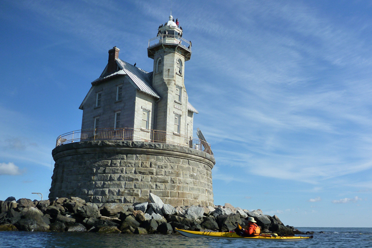
Race Light on the haunted Race Rocks is on the far southern edge of Fishers Island Sound.
Other Options Another good access spot to Fishers Island Sound farther east is Barn Island Management Area on Little Narragansett Bay, not far from Watch Hill, Rhode Island. Barn Island is the only major boat ramp in the area that is protected and that gives you access both to Block Island Sound and to Fishers Island Sound. Sandy Point Island and Napatree Beach help provide the buffer zone.
Barn Island is an 800-acre state wildlife preserve with lots of tidal marsh, great bird watching, clear saltwater, and good swimming and exploring. Many paddlers make a day trip out of paddling from Barn Island to Stonington, Mystic, and Groton on the Thames River; one Connecticut paddling group often puts in here during a full moon and paddles up to the Stonington for dinner and back.
The free, state-owned public launch attracts many motorboats. In the past, on a summer weekend, cars were parked for at least a mile up the road, and early morning arrival is necessary. You may be able to grab a parking place from a departing fisherman. The bay channel has extremely heavy motorboat use during summer, particularly waterskiing boats. Always choose the shortest crossing possible. The best plan is to visit in spring and fall.
To reach the launch ramp from U.S. 1, turn off at Greenhaven Road, then within 50 feet onto Palmer Neck Road, and take it all the way to the end following signs to Barn Island.
1Go back: A bascule bridge is a moveable bridge with a counterweight that continuously balances a span, or "leaf", throughout its upward swing to provide clearance for boat traffic. It may be single- or double-leafed. The name comes from the French term for balance scale, which employs the same principle.
